Simply put, a pseudolite is a GPS satellite placed on the ground. Pseudo-satellites are capable of transmitting signals similar to GPS, and their combined positioning with GPS adds observational measurements and has a lower elevation angle. Therefore, the geometric structure of the satellite positioning can be significantly enhanced, and the additional observations are also beneficial to enhance the solution of the GPS ambiguity and improve the accuracy, thereby improving the usability, stability and reliability of the entire system. Even in some cases where GPS satellite signals cannot be received, GPS satellites can be completely replaced to achieve special applications.
This article refers to the address: http://
For the GPS global positioning system, its positioning accuracy, availability and reliability depend on the number of satellites observed and the geometric structure of the satellite constellation. Under the condition that the observation conditions are not ideal, the number of satellites that can be observed and the geometric structure of the satellite are usually not ideal, and it is difficult to meet the needs of precise positioning. Under certain extreme conditions, such as indoors or underground, in a tunnel, satellite signals are not received at all, and GPS cannot work. On the other hand, although the GPS measurement can achieve higher accuracy in the horizontal direction, the positioning accuracy in the vertical direction is poor, and the error is usually 2 to 3 times of the horizontal positioning error, which is difficult to meet the requirements of some sophisticated applications.
The use of pseudo-satellite positioning technology compensates for the shortage of low-altitude satellites in GPS observations. The advantages are reflected in two aspects: 1. The number of available stars is increased, that is, the additional effective observation is added, which is beneficial to the positioning solution; 2. A notable feature of pseudo-satellite is that its elevation angle is very low and the signal needs to pass through the ionosphere. Combining such a low-height pseudo-satellite with GPS can effectively improve the geometric structure and improve the positioning accuracy.
Advantages of GPS and pseudolite combination positioning:
· Expanded positioning area and time slot
· Improved positioning solution speed and accuracy
· Enhanced reliability of the positioning system
Second, application introduction
Poor constellation geometry will result in poor geometric accuracy factors, especially for vertical geometry factors. However, this situation in which the geometrical distribution of satellites is degraded due to unfavorable terrain obscuration of satellite signals is very common in water conservancy and hydropower projects. In these areas, the stability and reliability of GPS monitoring will be greatly reduced. To improve the monitoring effect, an effective means is to join the pseudo-satellite for combined positioning.
The Dongjiang Dam is located in Zixing City, the upper reaches of the Xiangjiang River. It consists of Dadongjiang Power Station and Xiaodongjiang Power Station. Dadongjiang Hydropower Station is a hydropower project that is mainly based on power generation and has comprehensive benefits such as flood control and shipping. The barrage is a concrete double-curved arch dam with an elevation of 294m and a maximum dam height of 157m. The dam site is located in the upper section of the Dongjiang Gorge, and the height of the two sides is greater than 500m. The Xiaodongjiang Hydropower Station is 9km away from the Dadongjiang Hydropower Station. It is located in Dongjiang Town, Zixing City. It is mainly based on power generation, and has comprehensive utilization benefits such as urban and industrial water supply, and counter-regulates the discharge flow of the Dadongjiang Hydropower Station.
The power station is a riverbed water station. The main building of the hub consists of a flood discharge gate, a riverbed plant, and a non-overflow dam on both sides. The top elevation is 152m and the dam crest is 188m long. The Xiaodongjiang Hydropower Project has complicated engineering and hydrogeological conditions. After treatment, the operation effect is still good, but the basic seepage and displacement of the abutment should be highly valued. It is precisely because the Dongjiang Dam is a large-scale hydropower project with special significance and unique characteristics, it is essential to monitor its safety.
In addition to the monitoring points of the Dadong and Xiaodongjiang dams, the Dongjiang Dam Safety Monitoring also includes landslide monitoring points on both sides. The control area is large and there are many control points. The dam safety monitoring network consists of the Dadongjiang dam surface monitoring point, the Xiaodongjiang dam surface monitoring point, the landslide monitoring points on both sides of the strait, and two reference points. In the preliminary design, 12 monitoring points were laid on the Dadongjiang dam surface, 6 monitoring points were arranged on the Xiaodongjiang dam surface, 12 landslide monitoring points were arranged on both sides, and 2 reference points were set in the stable area away from the dam area. These 42 monitoring points and 2 reference points all use forced centering observation piers to form the Dongjiang dam safety monitoring network.
In the Xiaodongjiang dam area, the mountains are stacked and the surrounding mountains are steep. The whole dam is located between the "V"-type gorges. The monitoring area is large, the control points are many and the terrain conditions are poor. The GPS field monitoring data of the Xiaodongjiang Dam in January 2002 showed that the positioning effect of some of the measuring points was not ideal, especially the error of one of the monitoring points was extremely large. The reason is that the monitoring point is close to the mountain, and the entire southeast direction is completely blocked by the cliff, resulting in a bad DOP value, and ultimately affecting the effect of the positioning solution. As shown in Fig. 4-6, the shaded area in the figure is the GPS blind zone, and the GPS signal from the azimuth angle of 60° to 210° at the monitoring point is completely blocked by the mountain.
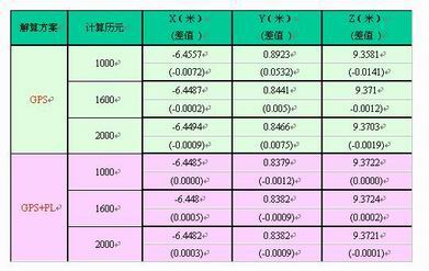
GPS and pseudo-satellite combination solution results
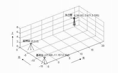
GPS and pseudo-satellite combined positioning diagram
We make OBD connector with terminal by ourselves, soldering type and crimping type are both available. Such as 16pin obd connector. OBD1, OB2, J1939, J1708, J1962, etc. Also molded by different type, straight type or right-angle type. The OBD connector cables used for Audi, Honda, Toyota, BWM, etc. We have wide range of materials source , also we can support customers to make a customized one to replace the original ones.
Automotive Diagnostic Connectors And Cables
Automotive Diagnostic Connectors And Cables,Obd Connectors,Reliable OBD Connector,Black OBD Connector,OBD Diagnostic Cable,OBD2 Connectors
ETOP WIREHARNESS LIMITED , https://www.etopwireharness.com